Point clouds
Point clouds are usually generated using laser scanners and can be imported from various file types. The following formats are supported:
- E57
- LAS
- LAZ
- Text files
Import point clouds
|
|
Interfaces toolbar |
| File menu > Import > Point cloud |
First, the point cloud file has to be selected.
Point cloud data from files in the format E57, LAS or LAZ are imported completely.
For text files some choices have to be made. In general, each line represents the XYZ coordinates of a single 3D point. A line may eventually also contain the colour of a point defined as RGB value or an intensity value. Depending on the scanner software, a line may additionally contain data like point number or other values.
A dialog window showing a preview of the first lines opens.
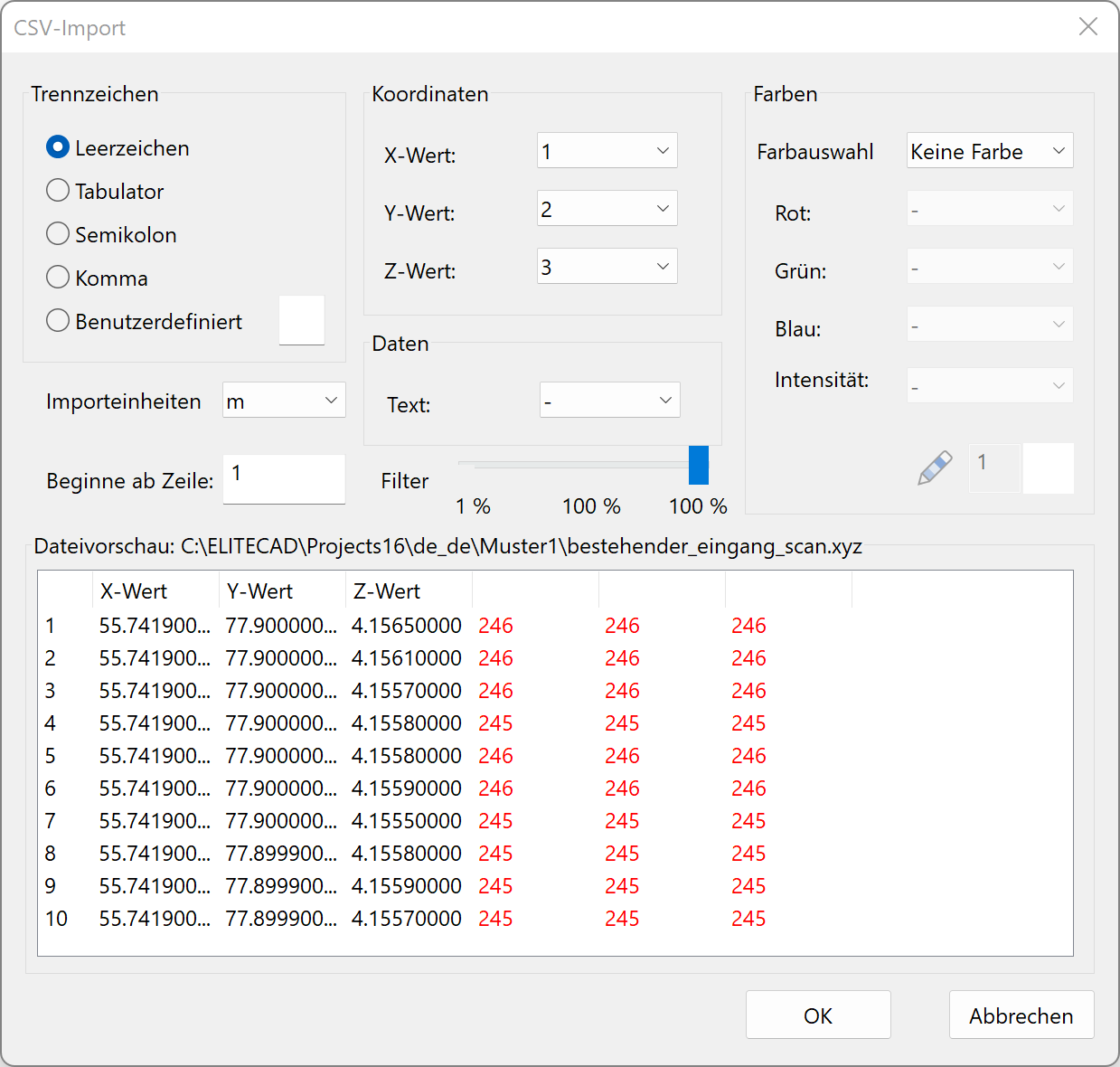
Following settings can be made:
- The separator for the values within a row
- Columns for the X-, Y-, and Z-value
- Columns for the R-, G-, and B-value (if colour import is active)
- The number of rows for the header or from which row the point import should begin
- The type of colour import (no colour, RGB, intensity)
- The column for an info text (optional, limited to 1000 entries)
In practice, there are often enormous amounts of data with millions of points that are at the expense of performance during the processing and frequently not even necessary in this level of detail. For this reason, ELITECAD offers the possibility to reduce the number of acquired points via a controllable filter.
After the selection has been made, you can start the import with  .
.
Each import process generates a new point cloud object. When combining multiple files, it is necessary to assure that all files refer to the same origin.
Imported points can be selected using all snap functions and can be used for measuring. Points can be deleted later on. Splitting and combining points clouds is supported as well. See chapter 3D OBJECTS > MODIFY > POINT CLOUD.
Batch importing point clouds
|
|
Interfaces toolbar |
| File menu > Import > Point clouds |
New · 16 R3 · Improvements
To import multiple point clouds simultaneously, choose this function. It works analogous to importing individual point clouds but offers the advantage of selecting an entire folder that contains multiple point cloud files.
As they will automatically be arranged in the drawing, it is necessary to assure that all files refer to the same origin.
Display
Info text
Using the image properties, the info text can be optionally displayed for the points. This is only a temporary graphical information and not part of a plan. As a result, the inserted info text cannot be printed. The graphical depiction of the info text also occurs if the point cloud is not selected.
Point size
The point size is configurable under SETTINGS > OPTIONS > DEPICTION > 2D/3D.