Depiction of simulations results
In principle, the following applies to all drawing structures created with the ELITECAD module tractrix curve:
- The vehicles created in the vehicle path are objects and are assigned to the Tractrix curve layer.
- The created contour lines are polygons and assigned to the Tractrix curve layer.
- The area requirement is outlined by a polygon. The created polygon is assigned to the Tractrix curve layer.
- The infill is assigned to the Tractrix curve layer.
Additionally, all elements created by the tractrix curve can be removed again using Undo.
Vehicle path

A sequence of outlines of the vehicle selected for the simulation is inserted into the drawing at the previously defined distance Increment. The following example classification structure is assigned to the newly created model with the display variant vehicle path:
Information of model: vehicle drawing
Level : GeoSchlepp
Class : 03 CarCampingtrailer
Group : (-60.233,15.357)
Layer (layer) : Tractrix_curve
Object (object) : Car_with_camping_trailer
Vehicle_name (Vehicle_name) : Car_with_camping_trailer
Algorithm (Algorithm) : Everling-Schoss
Increment (Increment) : 0.500000m
Vehicle_width (Fz_width) : 1760
Vehicle_length (Fz_L) : 4740
Wheelbase (Fz_AA) : 2700
Front_overhang (Fz_UH) : 1100
Turning_radius_diameter (FZ_WD) : 11.700
Coupling lenth (FZ_KP) : 3800
Trailer_width (A_width) : 2500
Trailer_length (A_LH) : 4000
Rear_overhang (A_UHH) : 2000
Drawbar_length (A_DL) : 3000
- The model is displayed according to the selected depiction options (e.g. is displayed vehicle path = vehicle drawing, contour lines = each relevant vehicle corner, area requirement = area requirement, area requirement with infill = area requirement with infill) of the corresponding designation for the displayed simulation result.
- The Class is assigned the name of the vehicle file without the file name extension. Blanks in the names of the vehicle file are replaced with an underscore.
- The Group is assigned the CAD-Coordinates of the starting point of the guide line.
- Das attribute Vehicle_name is assigned the vehicle name from the def-file. Blanks in the vehicle names are replaced with an underscore.
- Dem attribute Algorithm is assigned the previously selected simulation algorithm type.
- For Increment, the increment that was set for the simulation is selected.
As for the remaining attributes, they are all pulled from the simulation parameters, the selected vehicle dimensions and vehicle properties and documented. That means, with this data in hand, any tractrix curve created can be reproduced at a later time.
Contour lines

The (outer) curves describing the important points of the vehicle outline during a simulation are drawn.
The following example classification structure is assigned to the newly created model with the display variant Contour line:
Information of model: A1_axle_left
Level : GeoSchlepp
Class : TractorTrailer  Group  : (-60.208,15.797)
Layer (layer) : Tractrix curve
Object (object) : Tractor_with_trailer
Vehicle name (Vehicle name) : Tractor_with_trailer
Algorithm (Algorithm) : Everling-Schoss
Increment (Increment) : 0.500000m
Vehicle_width (Fz_width) : 1810
Vehicle_length (Fz_L) : 3390
Wheelbase (Fz_AA) : 2390
Rear_overhang (Fz_UH) : 500
Turning_radius_diameter (FZ_WD) : 7.000
Coupling length (FZ_KP) : 2890
Trailer_width (A_width) : 2220
Trailer_length (A_LH) : 5200
Rear_overhang (A_UHH) : 2200
Drawbar_length (A_DL) : 4100
The label of the model A1_axle_left means that the selected contour line is the line that describes the path of the point on the outer left of the axle of the 1st trailer part.
The trailer in the vehicle combination Tractor with trailer is a single-axle trailer. The contour line A1_axle_left ", in this case (left curve), is the contour line of the vehicle combination that is furthest to the inside.
Area requirement

The area needed by the selected vehicle combination is represented by a closed polygon.
The following example classification structure is assigned to the newly created model with the display variant Area Requirement:
Information of model: Arearequirement
Level : GeoSchlepp
Class : Semi-trailer_truck
Group : (-59.863,14.867)
Layer (layer) : Tractrix curve
Object (object) : Semi-trailer_truck
Vehicle name (Vehicle name) : Semi-trailer_truck
Algorithm (Algorithm) : Everling-Schoss
Increment (Increment) : 0.500000m
Vehicle_width (Fz_width) : 2500
Vehicle_length (Fz_L) : 6080
Wheelbase (Fz_AA) : 3800
Rear_overhang (Fz_UH) : 850
Turning_radius_diameter (FZ_WD) : 15.800
Coupling length (FZ_KP) : 3070
Trailer_width (A_width) : 2500
Area requirement with infill
The area needed by the selected vehicle combination is represented by a closed polygon with infill.
The following example classification structure is assigned to the newly created model with the display variant Area requirement with infill:
Information of model: Arearequirementinfill
Level : GeoSchlepp
Class : Semi-trailer_truck
Group : (-59.863,14.867)
Layer (layer) : Tractrix curve
Object (object) : Semi-trailer_truck
Vehicle name (Vehicle name) : Semi-trailer_truck
Algorithm (Algorithm) : Everling-Schoss
Increment (Increment) : 0.500000m
Vehicle_width (Fz_width) : 2500
Vehicle_length (Fz_L) : 6080
Wheelbase (Fz_AA) : 3800
Rear_overhang (Fz_UH) : 850
Turning_radius_diameter (FZ_WD) : 15.800
Coupling length (FZ_KP) : 3070
Trailer_width (A_width) : 2500
Trailer_length (A_LH) : 13610
Rear_overhang (A_UHH) : 4251
Drawbar_length (A_DL) : 7750
Turning radius diameter
If a steering solution is required during the simulation along a guiding line that is not possible with the turning radius diameter stored in the vehicle master data, the following error message appears:
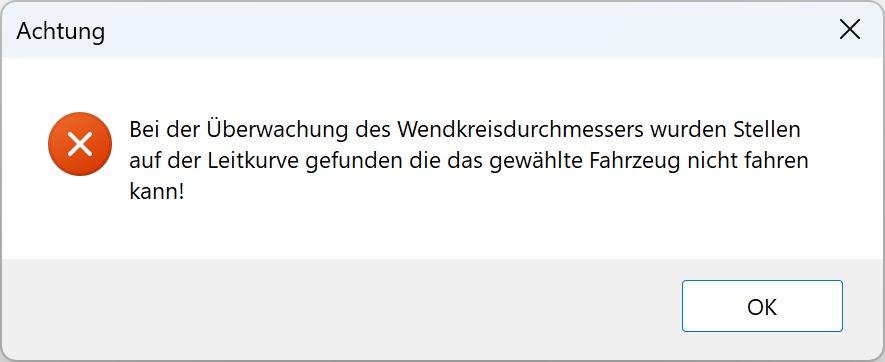
The problem area is marked with a circle for the user in the drawing. The system default colour for the circle is red. The colour and the line type for the error markings can be modified by clicking the Assign pen and line types button found in the tractrix curve parameter window and changing the settings for the Warning markers.

The following example classification structure is assigned to the markings of the problem areas within the newly created model:
Information of model: Error
Level : GeoSchlepp
Class : Road train
Group : Turning radius
Layer (layer) : Tractrix curve
Object (object) : Semi-trailer_truck
Algorithm (Algorithm) : Everling-Schoss
Increment (Increment) : 0.500000m
Vehicle_width (Fz_width) : 2500
Vehicle_length (Fz_L) : 9700
Wheelbase (Fz_AA) : 5280
Rear_overhang (Fz_UH) : 2920
Turning_radius_diameter (FZ_WD) : 20.600
Coupling length (FZ_KP) : 7700
Trailer_width (A_width) : 2500
Trailer_length (A_LH) : 7450
Wheelbase (A_AAH) : 4840
Rear_overhang (A_UHH) : 1260
Drawbar_length (A_DL) : 3410
Correct guide line

Even if the option Round guide line in the tractrix parameter window is selected, it can happen that the guide lines are not automatically corrected at a point. This can happen when, for example, the straight-line segment is too short to allow for automatic rounding. If this occurs the following error message is shown:
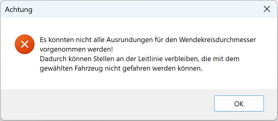
The points on the guide line where no sufficient corrective rounding could be implemented are marked in the drawing with a circle. The pen and the line type for these circles are defined in the same way as the problem areas with the turning radius diameter from the Tractrix curve parameter window > Assign pen and line types > Warning markers.

Information of model: Error
Level : GeoSchlepp
Class : wd=20.600m
Group : Rounding
Layer (layer) : Tractrix curves
© GEO DIGITAL GmbH